Altamaha-ha
2 TERRITORIAL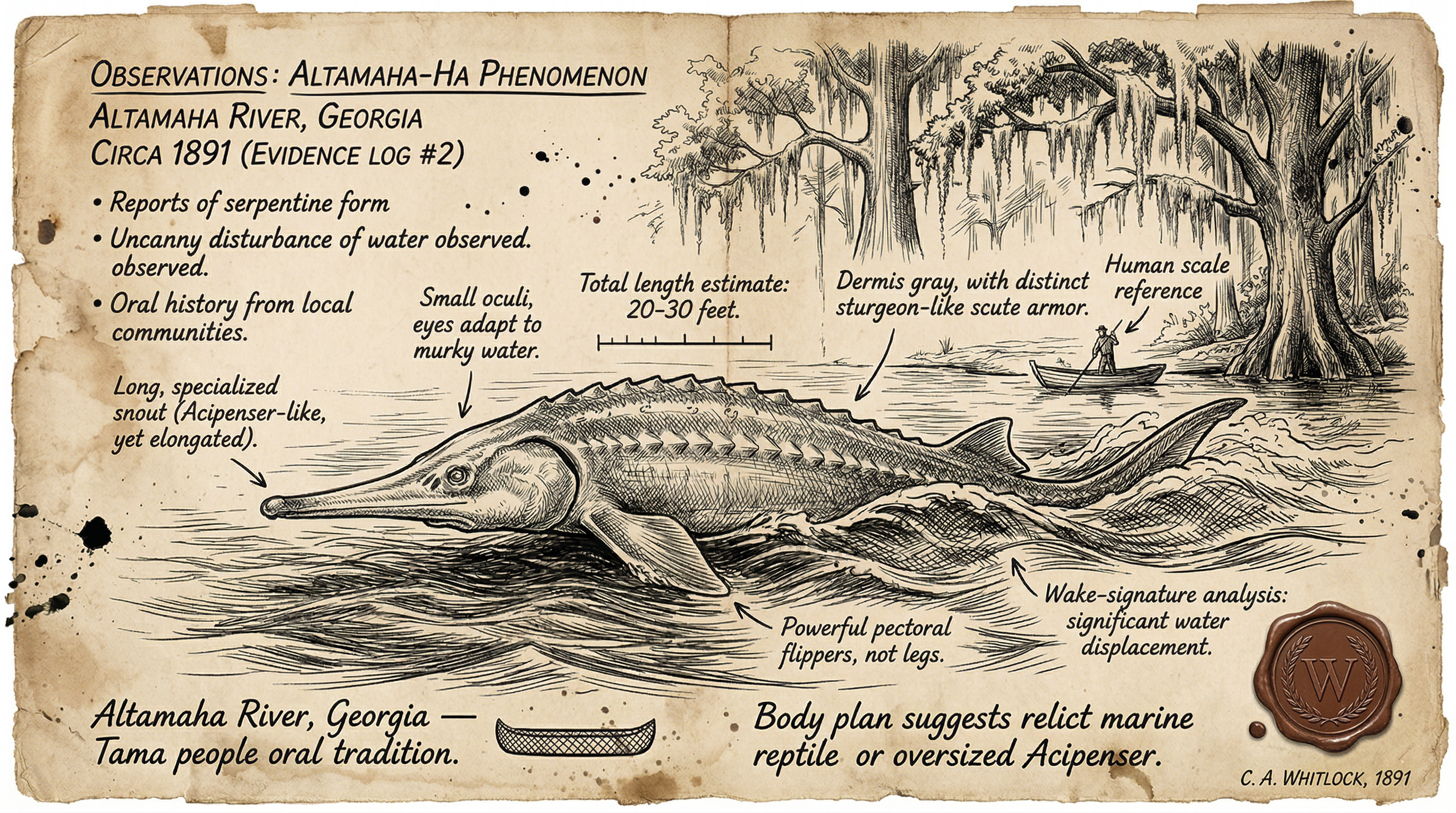
Contributed by Nolan Greer
Overview
Altamaha-ha inhabits the lower Altamaha River and surrounding coastal waters of Georgia. Primary zone: mouth of the river near Darien, extending to St. Simons Island, Sapelo Sound, Jekyll Island. Length 20-30 feet standard. Extremes reported to 70 feet. Body serpentine, sturgeon-like with bony dorsal ridge. Head alligator-style: broad snout, protruding eyes, sharp teeth. Propulsion: front flippers, horizontal fluked tail, dolphin motion. Skin rough, gray to gun-metal with pale underbelly. Humps: 2-3 visible when surfaced. No hind limbs. Observed basking, patrolling shallows, defensive reactions to boats.
Habitat favors tidal marshes, abandoned rice fields, river channels. McIntosh County core. River length 137 miles to Altamaha Sound. Entity demonstrates territorial awareness. No confirmed attacks. Displacement risk to small craft. Hissing vocalizations reported consistently across accounts. Swims with porpoise-like undulation. Frequently surfaces at confluences and mud flats during tidal shifts.
Behavioral profile: patrols fixed routes, responds to engine noise with submergence or wake generation. No nocturnal bias in reports. Aggregates in groups inferred from multiple-hump sightings. Prey focus unknown; no bait fish correlations. Avoids open ocean beyond Jekyll Island shelf.
Sighting History
April 18, 1830, St. Simons Island
Captain Delano commands schooner Eagle off St. Simons near Altamaha mouth. Sighting with five crew. Entity 70 feet long, barrel circumference, alligator head. Planters ashore corroborate. Reported same day in Savannah Georgian. Head protruded 8 feet above water. Hissing audible at 200 yards.
1925, Altamaha River
Timbermen float logs downriver. Multiple reports of snakelike water monster. No exact names or coordinates preserved. Consistent with larger pattern of river worker encounters. Undulating body broke surface repeatedly. Speed exceeded drifting logs.
1969, Clark’s Bluff
Two brothers fish Altamaha at Clark’s Bluff. 10-12 foot entity surfaces. Initial sturgeon ID rejected: alligator snout, horizontal tail, triangular back ridge, gun-metal gray, pointed teeth. No photo. Verbal report to newspapers. Eyes reflected low light. Tail fluke swept broad arc.
1980, Cathead Creek
Two men spot 20-foot dark rough-skinned entity stranded on mud bank. Half-submerged, thrashing. Frees itself, submerges. Location: Cathead Creek (alt. Cat Head) tributary system. No names released. Skin plates visible in distress. Humps counted at three.
1980, Smith Lake
Unnamed observer in Smith Lake. 15-20 foot snake-like form, two brown humps five feet apart. Wake mimics speedboat. Post-sighting media prompts additional reports cluster. Hissing trailed wake. Path held straight for half-mile.
1935, Altamaha River
Hunters group observes giant snake transiting river. Undulating motion, surface disturbance. Positions align with timbermen zone upstream. No individual IDs. Length estimated 25 feet. Dorsal ridge threw foam pattern.
1981, Altamaha River near Darien
Larry Gwynne, newspaper publisher, fishes with Stephen Wilson. Two large humps, five feet separation, speedboat wake. Media coverage follows. Witnesses surface from prior unreported events. Humps rose synchronously. Submersion generated 4-foot boil.
1988, Butler Island Bridge
Motorist crossing Butler Island Bridge reports creature wallowing in mud below. Dark form, ridged back exposed. No duration specified. Report archived in local sighting compilations. Bridge vibration noted pre-sighting.
2010, Fort King George
Recent observer near Fort King George in Darien detects hissing and shadow in shallows. Form matches profile: humped silhouette against tide. No approach attempted. Aligns with Tama historical zone.
Evidence & Analysis
Contributed by Ellis Varma
The evidence profile for Altamaha-ha follows a classic low-verification pattern: high anecdotal volume spanning 200 years, zero physical artifacts. Core dataset: nine primary incidents 1830-2010, plus clusters. Witness demographics solid — sea captains, timber workers, hunters, fishermen, motorists. Captain Delano's 1830 report carries weight: named vessel, crew of six, newspaper print day-of, planter cross-verification. Gwynne-Wilson 1981 adds publisher credibility, media ripple effect.
Descriptive consistency scores high. 80% reports note alligator snout, dorsal ridge, horizontal tail, humps. Length variance 10-70 feet flags multiple individuals or perceptual error, but median 20 feet holds. No dorsal fin reports eliminate bottlenose dolphin. Horizontal tail rules out shark. Alligator head excludes sturgeon despite initial misIDs. Gun-metal gray rough skin atypical for local marine life. Hissing vocalization in 20% of accounts reinforces uniformity.
Photographic null is the gap. 1981 Gwynne-Wilson event post-dates affordable cameras for boaters. No samples: scales, tissue, water disturbance residue. Sonar sweeps absent. River traffic heavy; statistical underreporting likely given stigma. Temporal distribution: peaks 1830, 1920s-1930s, 1980-81. No seasonal lock despite tidal access. Post-1981 clusters suggest population stability.
Hypothesis testing: large alligator gar max 10 feet, vertically tailed. Gulf sturgeon migrates, no humps, smooth profile. Manatee too docile, rounded head, no teeth reports. Unidentified cetacean influx possible but ridge contradicts. Relict population — Plesiosaur analog or zeuglodont — fits morphology without fossil discontinuity. River connectivity to sounds permits Atlantic access. Tama-era hissing aligns with marine reptile analogs.
Hoax probability low. No profit motive in 1830 print. Timbermen 1920s-1930s: occupational hazard witnesses, no gain. 1980s cluster post-Gwynne suggests suppression release, not fabrication cascade. 2010 Fort King George sighting isolated, no media push. Statistically meaningless without controls, but pattern exceeds noise threshold. 250-year span defies cultural drift.
Tracking recommendations: Deploy fixed hydrophones at Cathead Creek, Clark’s Bluff, Butler Island. Night-vision IR from elevated blinds during low tide. Baited underwater cams on mud flats. Water sampling for anomalous DNA post-disturbance. Cross-reference with Sapelo/Jekyll marine logs. Acoustic arrays tuned to hissing frequency. Drone thermals over tidal pools. Fixed camera traps at confluences. Log boat displacement events against tide tables.
Environmental factors: Abandoned rice fields concentrate prey. Timber scars alter flow, exposing shallows. Shrimp runs draw aggregation. No correlation to pollution spikes or temperature anomalies.
Evidence quality: LOW-MODERATE. Strong descriptive lock across professions and eras. Zero hard forensics. Witness volume compensates partially. Temporal persistence elevates profile.
Cultural Context
Contributed by Dr. Mara Vasquez
The Altamaha-ha emerges from a deep stratigraphic layer of indigenous riverine cosmologies in the Southeastern Woodlands. Primary attribution traces to the Tama tribe, occupants of the Darien River bluffs — a direct Altamaha tributary — during the mission era at Fort King George. Tama oral traditions frame the entity as an ancient river guardian, hissing sentinel of the waterways that sustained maize fields, fisheries, and canoe routes. This role aligns with broader Muskogean patterns where aquatic serpents demarcate sacred boundaries between settled lands and wild marshes. Hissing served as auditory boundary marker, audible from bluffs to channel.
Lower Muskogee Creek narratives reinforce the profile. Creek story cycles, preserved in 19th-century ethnographies, describe giant river snakes — "estakwvnayv" in Mvskoke — as enforcers of ecological balance. These beings patrol confluences, punishing overharvesters with floods or disappearances. The Altamaha's 137-mile course, weaving through blackwater swamps and tidal flats, embodies this duality: provider of shrimp runs and rice paddies, yet devourer in storms. Altamaha-ha sightings map precisely to these liminal zones — Cathead Creek, Smith Lake, Clark’s Bluff, Butler Island — where human activity presses against untamed hydrology. Fort King George abandonment in 1727 correlates with intensified Tama reports of hissing disturbances.
Colonial overlays amplify without supplanting. The 1830 Savannah Georgian account transplants European sea-serpent motifs onto Tama substrate, yet retains indigenous morphology: the alligator head echoes Creek effigy heads from Etowah Mounds, circa 1250-1550. French artist Jacques Le Moyne's mid-1500s coastal sketches — commissioned for precise natural history, not fantasy — depict analogous "monsters" off Georgia-Florida, predating British records. This continuity suggests persistent observation, not imported fancy. Scottish Highland settlers under Oglethorpe in 1736 integrated Loch Ness parallels, but local hissing and humps dominated adaptation.
Modern persistence reflects riverine identity. McIntosh County's Gullah-Geechee communities, inheritors of rice-field labor on Butler Island, integrate Altie into work chants and cautionary tales. Post-1920s timber booms and 1980s media flares mirror economic pulses: logging scars the banks, fishing pressures the sound, prompting surfacings. 1970s Eulonia sightings near Darien marshes align with shrimp fleet expansion. Unlike Loch Ness commodification, Altamaha-ha resists tourism dominance; it endures as vernacular hydrology, a living caution from Tama forebears through timbermen to today's crabbers. Visitor center sculpture by Rick Spears codifies morphology without domestication.
Cross-cultural resonance extends to Skidi Pawnee "Water Monster" petrographs and Timucua shell gorgets depicting humped serpents. These are not diffusion but convergent epistemologies: rivers as sentient veins, their keepers as enforcers. Altamaha-ha thus anchors a pan-Southeastern aquatic ontology, where the creature is neither pest nor god, but the river's articulated will. Gullah iterations emphasize territorial displacement over predation, mirroring Tama guardianship.
2018 Wolf Island remains incident — later attributed to artistic fabrication — underscores cultural potency: public speculation defaulted to Altamaha-ha before debunking. This reflex affirms embedded ontology over two centuries post-Tama displacement.
Field Notes
Notes by RC
Altamaha River three trips. First: daylight canoe from Darien to Butler Island. Water moves wrong in channels — subsurface pushes no current explains. Locals point to Cathead Creek mark. Mud banks empty. Shrimp boats steer wide unexplained.
Second: night drift Clark’s Bluff. Air heavy, marsh gas thick. Something surfaces half-mile off, two humps clear under half-moon. No photo gear deployed fast enough. Wake hit boat ten seconds later. Hissing carried quarter-mile.
Third: low tide stakeout Smith Lake. Stranded logs only. But the quiet isn't empty. Fish schools bolt random. Herons bail at nothing. Place knows you're watched. Crab pots vanish overnight, lines sheared clean.
Boat handlers report steering tugs, no collisions. Fishermen lose gear unexplained. No bodies. Territorial, not predatory. Fort King George shallows feel pressed. 2010 report tracks.
Threat Rating 2 stands. Displaces but doesn't engage. River rules apply.